The minibus from Shaoguan East Station smelled of dried tangerine peel and brake dust. I wedged my pack between a sack of rice and a farmer’s bamboo stool, and we climbed out of the basin into air that turned cool enough to see your breath. Two hours later the driver shouted the stop, and I stepped onto gravel beside a ranger booth where a single red lantern swung in the wind. That was my first afternoon in Nanling — no ticket queue, no tour group, just the sound of water falling somewhere below the ridge.
Understanding the terrain
Nanling sits on the spine that separates Guangdong from Hunan. The park protects a stretch of the Nanling Mountains where the rock folds into knife-edged ridges and deep, shaded valleys. Elevation runs from roughly 400 meters at the gate to 1,902 meters at the summit of Shikengkong, the highest point in Guangdong. Because the range catches moist air rolling off the South China Sea, the slopes stay green year-round — pine, fir, and broadleaf evergreen mixed with bamboo thickets. In spring the rhododendrons bloom in corridors of pink and white; in autumn the maples turn the ridgelines the color of hot coals. Winter can bring a dusting of snow on the peaks, while summer afternoons often end in thunderstorms that clear by dusk.
Getting there without a private car
Most visitors arrive through Shaoguan. High-speed trains reach Shaoguan Station (the older downtown stop) and Shaoguan East Station (the newer hub on the Guangzhou–Wuhan line). From Shaoguan East, walk out the main exit and turn left across the forecourt. A white minibus with a hand-painted “南岭国家森林公园” sign waits beside the taxi stand. It departs three times a day — early morning, midday, and mid-afternoon — and returns on a matching schedule. The ride follows the winding G323 through Ruyuan County, climbing switchbacks above tea terraces before dropping into the park entrance valley. Allow two hours; motion sickness tablets help if you’re not used to mountain roads.
- Train to Shaoguan East (high-speed) or Shaoguan (conventional).
- Exit station, cross forecourt to the left, look for the white minibus with red characters.
- Buy ticket from the driver (cash or mobile pay).
- Ride ~2 hours to the main gate.
If you miss the last bus, a shared taxi from the same forecourt will take you for about ¥60 per seat if you can fill four people. Solo travelers sometimes wait half an hour for others to appear. Drivers hand out business cards — save one; you’ll need a ride back to the station or to trailheads deeper in the park.
Tickets, permits, and the Orange House trick
The standard entrance fee is ¥60 for a single day. Students with a valid Chinese university ID pay half. The ticket is date-stamped, so a midnight arrival doesn’t buy you two calendar days — unless you stay at the Orange House (橙子屋), a cluster of simple rooms near the Qinshui Valley trailhead. Guests there receive a two-day park pass at check-in. The rooms have hot water, thick quilts, and a communal kitchen where hikers swap trail beta over instant noodles. Book by WeChat during peak season (spring flower bloom and autumn color); walk-ins work in the quiet months.
Moving around inside the park
There is no internal shuttle. The main sights — Little Yellow Mountain (小黄山), the Rufeng Waterfall Group (乳峰瀑布群), Qinshui Valley (清水谷), and the summit trail to Shikengkong — are spread along a 15-kilometer stretch of mountain road. Options:
- Hired driver: Flag a parked taxi at the gate or call the card you saved. A full-day run to all major trailheads and back costs ¥150–¥200 if you share with two or three others. Solo price can climb to ¥300; bring a Chinese-speaking friend to negotiate.
- Self-drive: The road is paved but narrow, with hairpins and occasional rockfall. Parking lots at each trailhead fill by 10 a.m. on weekends.
- Hike between sites: The stone-paved paths connect most attractions. Walking from the gate to Little Yellow Mountain takes 40 minutes; Qinshui Valley to the waterfall group is another hour. Carry water — taps are rare.
Three main hiking routes
All trails are built with stone steps, handrails, and occasional boardwalks. Signage is bilingual (Chinese/English) at major junctions.
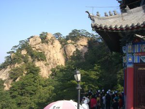
- Little Yellow Mountain Loop (3–4 hours round trip): Steady climb through pine forest to a series of granite tors with 360-degree views. The “Yellow” comes from the lichen-streaked rock, not the foliage. Best in morning light; afternoon clouds often obscure the peaks.
- Rufeng Waterfall Group (2–3 hours one way from gate): A descending staircase drops into a gorge where five falls cascade over basalt ledges. The lowest pool is deep enough for a cold plunge in summer. Mist keeps the rocks slick — wear shoes with grip.
- Shikengkong Summit (6–8 hours round trip from Qinshui Valley): The longest day. Start before 7 a.m. The trail climbs through cloud forest, passes a weather station, and ends on a broad alpine meadow. On clear days you see the Pearl River Delta shimmering 150 kilometers south. Wind at the top can cut through a fleece; pack a wind shell.
Swimming, camping, and other things to do
Aside from hiking, the park allows swimming in designated pools below the Rufeng falls and in the slower bends of Qinshui Creek. Lifeguards are not present; currents strengthen after rain. Camping is permitted only at the designated site near Orange House — flat grass, a few fire rings, and a compost toilet. No fires outside the rings. If you prefer a roof, the park’s own guesthouse (南岭山庄) offers dorm beds and private rooms; book through the same WeChat mini-program as the entrance ticket.
When to go and what to pack
Spring (third to fifth lunar months) brings rhododendrons and mild temperatures — 12–20 °C at mid-elevation. Summer (sixth to eighth lunar months) is warm but wet; trails can be slippery, and leeches appear in damp grass. Autumn (ninth to eleventh lunar months) delivers the famous red-maple corridors and stable weather — my favorite window. Winter (twelfth lunar month to second) is quiet, sometimes icy on the summit; bring microspikes.
- Sturdy hiking shoes with drainage (streams cross the path).
- Light rain shell — storms roll in fast.
- Layered clothing: base, fleece, wind layer.
- Headlamp (summit hike starts in dark).
- Snacks, electrolyte powder, 2 L water capacity.
- Small first-aid kit and leech socks if hiking in summer.
- Cash (¥100–¥200) for drivers and snacks; signal can drop on ridges.
Common mistakes and local expectations
First-timers often underestimate the vertical gain — the stone steps are relentless, and altitude makes breath come shorter above 1,500 meters. Pace yourself; the park is not a race. Another error: arriving at the gate after 10 a.m. on a holiday weekend and finding the parking lot full, then walking the road in flip-flops. Locals expect hikers to yield on narrow stairs — step aside, let the faster party pass. Litter bins exist only at trailheads; carry out everything, including fruit peels. And don’t feed the macaques near Little Yellow Mountain — they’ve learned to unzip packs.
On my last visit, an elderly ranger at the Rufeng junction handed me a warm steamed bun from his lunch box, pointing at the trail marker for the summit. “Slowly, slowly,” he said. “The mountain doesn’t move.” I ate the bun, adjusted my pack, and kept climbing. That’s the rhythm here — one stone step after another, through pine scent and mist, until the view opens.